


Welcome to Leg Day
Welcome to Leg Day
Plus, seven questions I had after spending way too much time looking at the 2024 NYC Bike Map

It’s good to see you.
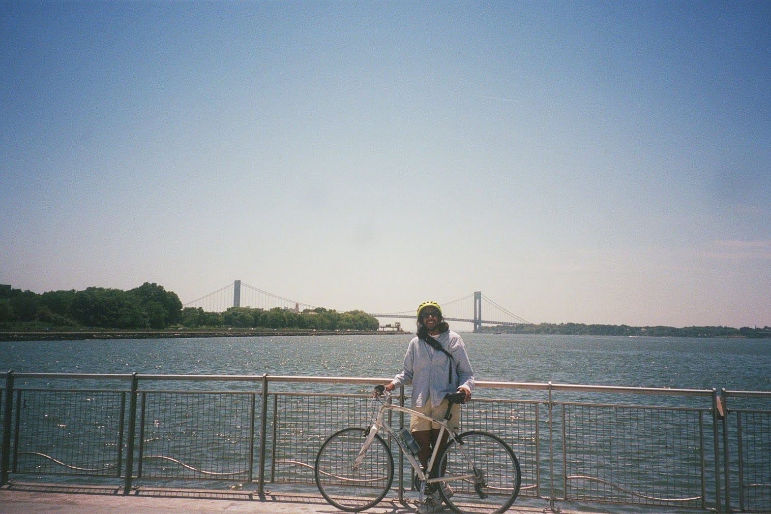
In 2023, I started biking in New York. I had always wanted to be a city cyclist, but I was pretty worried I'd get killed by a driver. To force my hand, I pitched a story to my editors at The Wall Street Journal called "How to Become a Cyclist Without Even Dying."1 With the help of a bunch of friends, the educators at Bike New York and encouragement from cyclists across the country, I set off for the Prospect Park loop. Somewhere along the long descent in the southwest corner, I realized I was yawping with glee.
When I've tried to explain the speed of this shift to anyone who doesn't ride, they kind of stare at me with horror. Cool for you, but I'm way too scared to try myself.
This bums me the hell out. So I decided to deal with the emotion the only way I know how: write my way through it.
The result is this newsletter, Leg Day, a manual for anyone in pursuit of joy on two wheels. Through interviews with bikers I’d follow to the end of the earth, essays about weird adaptations I’ve adopted in the saddle, reporting on the infrastructure we rely on, reviews of excellent gear, and weekly roundups of amazing group rides you should attend, I hope to make getting on a bike feel a lot less scary. I’m also planning to host rides and events for subscribers, including some secret ones for those upgrade to paid. I hope you’ll join one … I promise to spend the entire time gassing you up!
If you want to read more about the specifics of what you get with a paid sub, it’s all outlined on the about page. Here’s a link!
For our inaugural issue, let’s start simple. Did you know that the New York City Department of Transportation provides a pretty comprehensive map of all the bike lanes they’ve built each year? Oh, you did? Well, let’s take a look at it anyway.


According to the Wayback Machine, the 2024 NYC Bike Map [pdf] was uploaded to the Department of Transportation some time between April 27 and May 11. A representative from the Department of Transportation—yes, I wasted their time with this request—confirmed that they release the year’s map “each spring2.”
I’m generally pretty cynical about transportation departments. Across the country, most seem to spend all of their energy deciding whether to widen a highway, even thought it’s been proven over and over that isn’t a good way to reduce traffic3.
At least in New York though, the DOT deserves some credit. By all accounts, biking in New York used to be something you’d only do if you were a true hardo with a death wish. Former NYC DOT Commissioner Janette Sadik-Khan once told me pedaling through Manhattan resembled a cross between a ‘70s disaster film and “Mad Max.” It’s significantly less like that now, though I can cop to being a bit afraid of all the teens riding in the front baskets of electric Citi bikes. Witness me!
For more evidence of how much things have changed, take a look at the difference between the 2015 map (the oldest the DOT has on its website) and the one from this year. Many of the lanes we use today were there a decade ago, though a lot of them have been upgraded into protected Greenways. And plenty of neighborhoods like Bushwick that didn’t have any bike lanes at all a decade ago, now have thick networks that you can pretty easily use to get around.


That said, there are plenty of things to nitpick. I know for a fact that a lot of these Bushwick roads suck to ride. You’re constantly watching out for potholes, drivers that get too close and ravers who misjudge the curb height. But I’ll take DJs in K-holes over shared lanes with box trucks any day of the week.
As I scanned the map, I kept noticing odd details. Here, seven questions about it that may not have answers.
1. Biking with your AirPods Max doesn’t just make you look like a sucker who spent $550 on mediocre headphones, it’s also a crime???
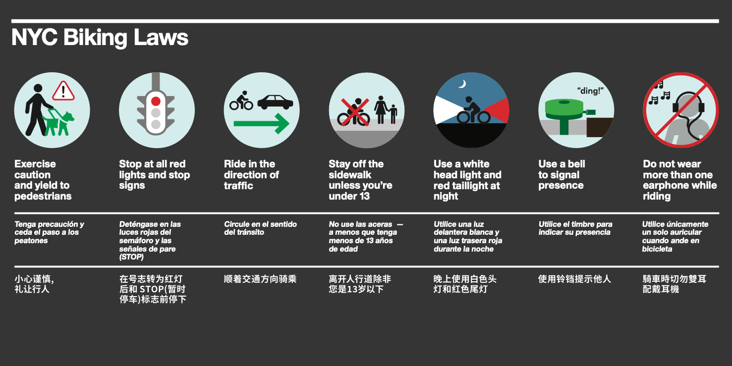
This graphic is so funny. You have to use a bell? When yelling “YO” at the top of your lungs is right there? And free?
2. There are actual factual trail rides in the city???


The thin reddish brown lines of the map indicate dirt paths or trails. I found three spread across the city. One up in Manhattan at Highbridge Park, one right next to the Greenway I take to get to Jacob Riis in Shirley Chrisholm State Park, and another in Queens at Cunningham Park. We should check them out!
3. What’s this oval shaped Greenway that doesn’t actually have any bike paths connected to it?
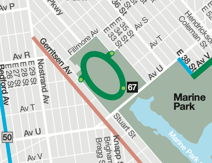
This is the Oval Hiking Path of Marine Park, apparently the largest park in Brooklyn. I had literally never heard of it until this moment. This does not seem to be an actual bike path, at least according to the satellite imagery I’ve looked at. Further in person study is required.
4. Why are there so many skate parks in Williamsburg?
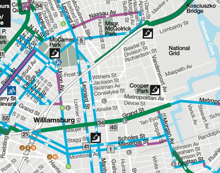
I love that the maps have a specific symbol for skateparks and that it’s just a person-less skateboard on a quarter pipe. Is it going up? Coming down? No way to tell. Skaters, hit me with your reviews of each of these … I’m sure there’s a consensus about which one is for posers4.
5. Do the bike lanes just stop in Long Island?
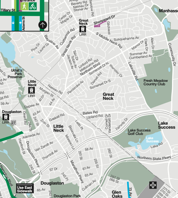
I’m willing to believe this is a result of the map’s scope and not necessarily the reality on the ground, but it’s weird that the lanes just end in Little Neck. But given that there’s a little shared lane up by the Great Neck LIRR stop, I’m worried the situation is actually just that ppl who live in Long Island don’t like bike lanes. Please tell me I am wrong!
6. Where are all the bike lanes in Queens?
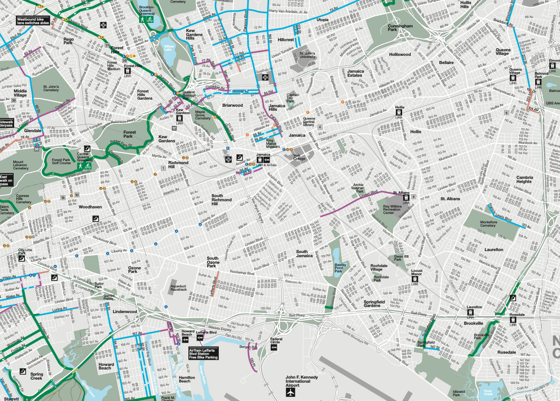
Seems like there’s basically no bike infrastructure between Forest Park and the Airport. That does track with my experience as a former Ozone Park resident (the most depressing six month period of my life). That said, there appears to be free bike parking at the AirTrain Lefferts station? Has anyone actually biked to their flight?
7. Why’s there no direct lane to LGA?
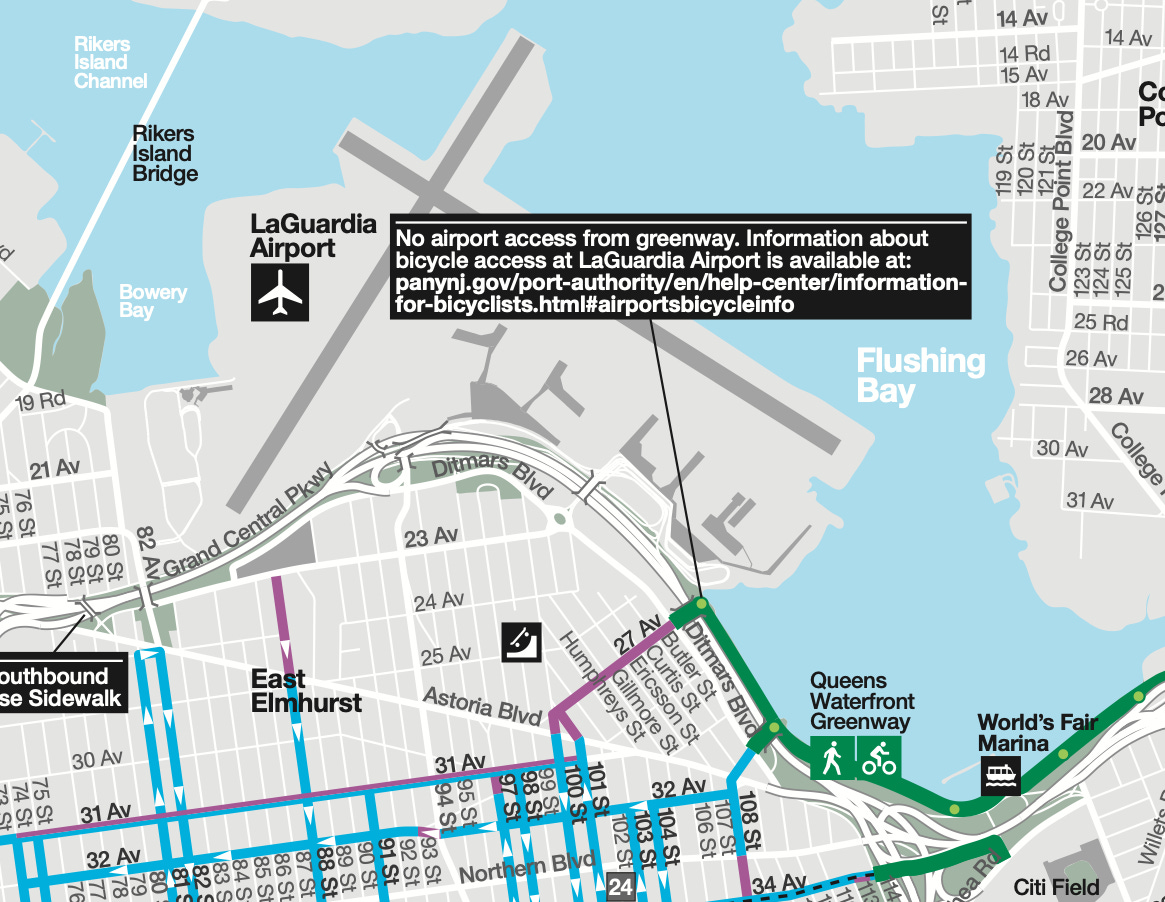
There’s literally a greenway that goes right next to it? What gives? Speaking of, did you see that TikTok about taking an electric Citi Bike with a carry-on sized backpack from Manhattan to the Citi Bike station next to the free airport shuttle bus? He spent under $20, but I think he had a Citi bike membership. Something to try!
7. Why does the path switch sides?


I hate when the prescribed bike path switches sides, especially because it’s always in parts of the city with horrendous traffic. These are the only three points where this happens that I could identify on the map, but I know of at least two others. I hope they’re noting it here because they have plans to fix it!
Take a look yourself! Notice anything I missed? Drop me a comment or a reply! Thanks for reading!
I’m still mad they wouldn’t let me. Here’s the link.
Full quote: “For your awareness, NYC DOT’s road redesigns don’t start until the weather warms. So the release of the map each spring largely reflects the work done over the prior year. “ Might as well have added a “you idiot” to the end of that first sentence. (Vincent, if you are reading this, thank you for answering my question I hope you don’t think I am an idiot.)
You can read about induced demand in this 2014 WIRED story or watch this 2024 Not Just Bikes video. It’s not a new concept.
My guess is McCarren.
yooooooo!! love this. i just got into cycling too and am an official butt pad bib chamois devotee. come bikepacking with me on the west coast <3
Leg day!!